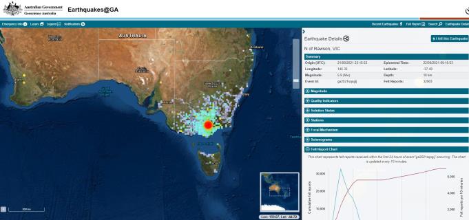
Yarra Ranges residents were left shaken across the region after a 5.9-magnitude earthquake originating from Woods Point hit in September 2021, with the incident now known to have been caused by a ‘blind’ fault line in the area according to new research led by experts at The Australian National University (ANU).
The earthquake was Victoria’s largest recorded earthquake since record keeping began around two centuries ago.
Lead researcher and a seismologist at the ANU Research School of Earth Sciences Dr Sima Mousavi said blind faults can pose a significant threat as they can generate large earthquakes but they are hidden from us.
“This can make it difficult to identify areas that are at risk from earthquakes, which can be dangerous for communities living nearby,” she said in a statement
“While blind faults may be more difficult to identify and study than faults with surface exposure, it is important to understand their location and behaviour and potential hazards in order to properly assess earthquake risk and take appropriate measures to protect communities and infrastructure.”
15 minutes after the initial event, a 4.0 (Mw) aftershock was also recorded.
Chief Scientist at the Seismology Research Centre Adam Pascale said despite being the epicentre, Woods Point suffered less from the quakes than even places like the Melbourne CBD.
“The effect of earthquakes really depends on what our structures are built on, if it’s on nice solid bedrock, it’s probably not going to shake as much or for as long as if you’re on soft soil or sediments. People in Woods Point said it didn’t even knock the cans off the shelf at the pub,” he said.
“An area like Melbourne is built has a lot of sedimentary rock and river silts which tends to shake and amplify the signal. If you’re living in an area like a mountainous area like Warburton there are likely to be earthquakes in the area, but how you feel it depends on where you are and what you’ve built there”
The Seismology Research Centre has seismic stations situated around Victoria, including one which was within 35km of the epicentre of the Woods Point earthquake and 20-30 stations within 100km of it.
Mr Pascale said a lot of Southeast Australia’s earthquakes are ‘blind’ because the compression our tectonic plate is under which often prevents them from rupturing the surface.
“In this case, this fault was aligned with the direction of compression. So it was one part sliding past another, so you don’t get plates coming over the top of each other like you see in animations about San Andreas, you don’t get the vertical offset at the surface which makes it easier to find,” he said.
“For this case, they even used satellite data and it was very hard to see anything, so this is one of those earthquakes that has mostly happened under the surface.”
Since the Woods Point earthquake, well over 1000 aftershocks have been recorded and continue to be every week, albeit very small ones.
The Seismology Research Centre posts a weekly earthquake map of Australia on their social media accounts of the same name for anyone interested or seeking information about earthquakes.

